
Stability index
- Any of several quantities that attempt to evaluate the potential for convective storm activity and that may be readily evaluated from operational sounding data.
- In the definitions, Tp and Dp correspond to the temperature and dewpoint at pressure levels p. Those most commonly used are the following.
-
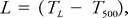
Showalter stability index: An index given by
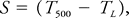 where TL is the temperature (°C) of a parcel lifted from 850 to 500 mb, dry-adiabatically to saturation and moist-adiabatically above that. As the index decreases to zero andbelow, the likelihood of showers and thunderstorms is considered to increase (Showalter 1947).
 - K-index: This index is due to George (1960) and is defined by
 The first term is a lapse rate term, while the second and third are related to the moisture between 850 and 700 mb, and are strongly influenced by the 700-mb temperature–dewpoint spread. As this index increases from a value of 20 or so, the likelihood of showers and thunderstorms is expected to increase.
 - Totals Indices: The Total Totals index is attributable to Miller (1972). It is defined as the sum of two indices:
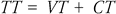 where VT is the Vertical Totals index, defined by
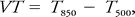
Avalue of about 40 corresponds to a dry-adiabatic lapse rate. For a moist- adiabatic lapse rate it is about 20 for T850 = 15°C, about 30 for T850 = 0°C. The Cross Totals index, CT, is defined by
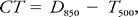 so is strongly influenced by the 850-mb moisture. Showers and thunderstorms become increasingly likely from TT values of about 30, and severe thunderstorms are considered likely for values of 50 or more.
 - Lifted index: This index, developed by Galway (1956), is
 so is nominally identical to the Showalter index, except that the parcel being lifted (dry- adiabatically to saturation and then moist-adiabatically to 500 mb) is defined by the dry adiabat running through the predicted surface afternoon temperature maximum and the mean mixing ratio in the lowest 900 m of the sounding. If no further heating is expected, as with a sounding taken in the late afternoon, then the mean potential temperature in the lowest 900 m of the sounding defines the dry adiabat used for the parcel. Numerous variations, focused on how the lifted parcel is defined, have been used since the original definition. The values of this index tend to be somewhat lower than those of Showalter, and the interpretation depends to some extent on how the lifted parcel is defined.
 - SWEAT index: (Or severe weather threat index; also abbreviated SWI.) Another index attributable to Miller (1972), used mainly for analyzing the potential for severe thunderstorms, is defined as
 where TT is the Total Totals index (set to zero if less than 49), V850 and V500 are the 850- and 500-mb wind speeds, and ΔV500 - 850 is the 500-mb wind direction minus the 850-mb wind direction, in degrees. The last term is set to zero if any of the following conditions are not met: 1) 850-mb wind direction is in the range from 130 to 250 degrees; 2) 500- mb wind direction is in the range 210 to 310 degrees; 3) the difference in wind directions is positive, or 4)both 850- and 500-mb wind speeds are at least 15 knots. No term in the formula is allowed to be negative. The severe thunderstorm threat is considered to increase from values of about 300 and higher; tornadoes are considered to increase in likelihoodfrom values of about 400 and up.
Showalter, A. K. 1947. A stability index for forecasting thunderstorms. Bull. Amer. Meteor. Soc.. 34. 250– 252.
George, J. J. 1960. Weather Forecasting for Aeronautics. Academic Press, . 673 pp.
Miller, R. C. 1972. Notes on analysisand severe storm forecasting procedures of the Air Force Global Weather Central. Tech. Rept. 200(R). Headquarters, Air Weather Service, USAF, . 190 pp.
Galway, J. G. 1956. The lifted index as a predictor of latent instability. Bull. Amer. Meteor. Soc.. 528–529.
índice de estabilidad
Se refiere a cualquiera de varias cantidades que intentan evaluar el potencial de actividad de tormenta convectiva y que pueden evaluarse fácilmente a partir de datos de sondeo operativo.
En las definiciones, Tp y Dp corresponden a la temperatura y al punto de rocío a niveles de presión p. Los más comúnmente utilizados son los siguientes:
Índice de estabilidad Showalter: Es un índice expresado por
donde TL es la temperatura (°C) de una parcela levantada de 850 a 500 mb, en seco adiabáticamente hasta la saturación y en húmedo adiabáticamente por encima de dicha temperatura. A medida que el índice disminuye a cero y por debajo, se considera que aumenta la probabilidad de lluvias ligeras y tormentas eléctricas (Showalter 1947).
Índice K: Este índice se debe a George (1960) y se define mediante
El primer término es un término de gradiente, mientras que el segundo y el tercero están relacionados con la humedad entre 850 y 700 mb, y son fuertemente influenciados por la diferencia entre la temperatura y el punto de rocío a 700 mb. Conforme este índice aumenta de un valor de alrededor de 20, se espera que aumente la probabilidad de lluvias ligeras y tormentas eléctricas.
Índices de totales: El índice total de totales se atribuye a Miller (1972). Se define como la suma de dos índices:
donde VT es el índice de totales verticales, definido por
Un valor de aproximadamente 40 corresponde a un gradiente adiabático seco. Para un gradiente adiabático húmedo es aproximadamente 20 para T850 = 15 °C, aproximadamente 30 para T850 = 0 °C. El índice de totales cruzados, CT, se define por
de modo que es fuertemente influenciado por la humedad a 850 mb. Las lluvias ligeras y las tormentas eléctricas se vuelven cada vez más probables a partir de valores de TT de aproximadamente 30, y las tormentas eléctricas peligrosas se consideran probables para valores de 50 o más.
Índice de ascenso: Este índice, desarrollado por Galway (1956), es
así que nominalmente es idéntico al índice Showalter, excepto que la parcela que está ascendiendo (adiabáticamente en seco hasta la saturación y luego adiabáticamente en húmedo hasta 500 mb) se define por el proceso adiabático seco que atraviesa el máximo de temperatura superficial pronosticado para la tarde y la proporción de mezcla promedio en los 900 m inferiores del sondeo. Si no se espera más calentamiento, como al realizar un sondeo al final de la tarde, entonces la temperatura potencial media en los 900 m más bajos del sondeo define el proceso adiabático seco utilizado para la parcela. Desde la definición original se han utilizado numerosas variaciones centradas en cómo se define la parcela que se está elevando. Los valores de este índice tienden a ser un poco menores que los de Showalter, y la interpretación depende en cierto grado de cómo se define la parcela elevada.
Índice SWEAT: (Se le llama índice de amenaza de tiempo severo; también abreviado SWI). Este es otro índice que se atribuye a Miller (1972), que principalmente se utiliza para analizar el potencial de tormentas eléctricas peligrosas. Se define como
donde TT es el índice total de totales (configurado a cero si es menor que 49), V850 y V500 son las velocidades del viento de 850 y 500-mb, y ΔV500 - 850 es la dirección del viento de 500 mb menos la dirección del viento de 850 mb, en grados. El último término se establece en cero si no se cumple alguna de las siguientes condiciones: 1) la dirección del viento de 850 mb está en el rango de 130 a 250 grados; 2) la dirección del viento de 500 mb está en el rango de 210 a 310 grados; 3) la diferencia en las direcciones del viento es positiva, o 4) las velocidades del viento de 850 y 500 mb son de al menos 15 nudos. Ningún término en la fórmula puede ser negativo. Se considera que la amenaza de tormenta eléctrica peligrosa aumenta desde valores de aproximadamente 300 y más; se considera que la probabilidad de tornados aumenta con valores de alrededor de 400 y más.